|
|
|
|

|

|
KARTOR is a provider of Geographic Information systems (GIS). We help clients visualize their data in a simple and direct way in
georeferenced contexts for strategic decision-making.
For 30 years, we have combined managerial experience with in-depth knowledge of GIS, using application development technologies
integrated with statistical, optimization and database management techniques.
We serve public and private companies in sectors such as environment, agriculture, mining, telecommunications, transportation, health,
education, urban planning, commerce, real estate registration, and the electoral sector.
|
|
|
|
|
|
|
Activities:
|
|
|
|
|
|
Techniques:
|
|
|
Routing
Geocoding
Remote Sensing
Data Cleaning
WebGeo
|
|
|
|
|
|
|
|

|
CASES
|
|
|
|
|
|
|
|
|
|
|
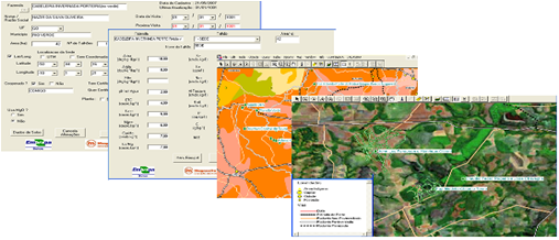
Farming System
Embrapa
Solos, Magnesita, Cooperativa COMIGO
|
|
|
|
|
Georeferenced application created by KARTOR to analyze information related to soil fertility.
The program collects, filters and cross-references soil data (soil analysis series) and climate data, agricultural productivity indicators on farms and a complete overview of the transport infrastructure.
|
|
|
|
|
|
|
|
|
|
|
|
|
|
|
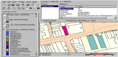
Municipal Real Estate Registry GIS
Municipal Government of Rio de Janeiro, IPP – Statistical Agency
|
|
|
|
|
The system supports the activities of the Health, Planning and Treasury Secretaries.
KARTOR updated existing maps based on aerophotogrametry and satellite imagery, field surveys and housing data sets..
|
|
|
|
|
|
|
|
|
|
|
|
|
|
|
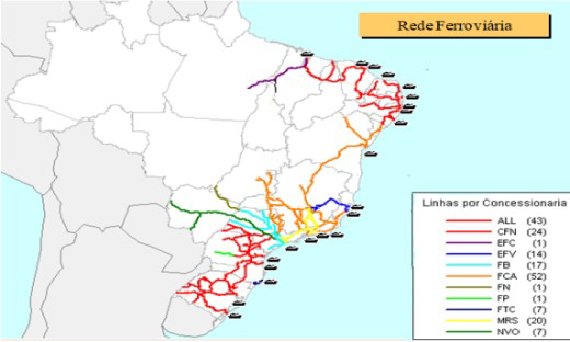
Brazilian Railway System
Federal Government Regulatorty Transportation Agency (ANTT), Federal University of Santa Catarina (UFSC)
|
|
|
|
|
KARTOR took part in the development group of the Brazilian railway network’s WEB GIS .
The system monitors infrastructure, safety and productivity indicators from the private concessionaires that manage the Brazilian railroads.
KARTOR also created the base map of the entire Brazilian railway network.
|
|
|
|
|
|
|
|
|
|
|
|
|
|
|
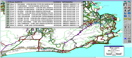
Bus Routing System - Rio de Janeiro
RIOÔNIBUS – Rio de Janeiro Bus operator Business Association
|
|
|
|
|
KARTOR vectorized over 900 bus lines of Rio de Janeiro and created the TRANSCAD routing system.
The system is useful for planning new routes, bus control and customer information activities.
|
|
|
|
|
|
|
|
|
|
|
|
|
|
|
Health Family Strategy Indicators
FAPERJ - Research Support Agency of Rio de Janeiro
|
|
|
|
|
Project financed by FAPERJ and jointly developed by UERJ (Rio de Janeiro State University), Estacio de Sá University and KARTOR.
The program imports data published by DATASUS (Ministry of Health's institution responsible for gathering data provided by the official sources of information), calculates the indicators of PMAQ (health family quality improvent Program), and displays it on thematic maps of the team´s regions.
|
|
|
|
|
|
|
|
|
|
|
|
|
|
|
GIS Health System
Cedaps, Fundação Vale
|
|
|
|
|
KARTOR implemented the Family Health GIS System for CEDAPS and Vale Foundation.
For each municipality, a survey is conducted of the territory of the Primary Care health teams.
GIS' thematic maps visualize the team indicators, published monthly by E-SUS.
The system has already been implemented in more than 30 municipalities in the Health Cycle.
|
|
|
|
|
|
|
|
|
|
|
|
|
|
|
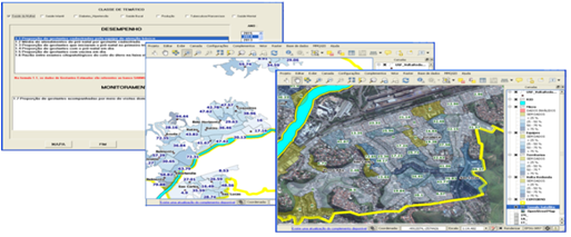
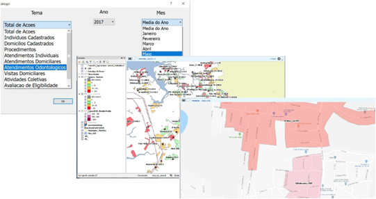
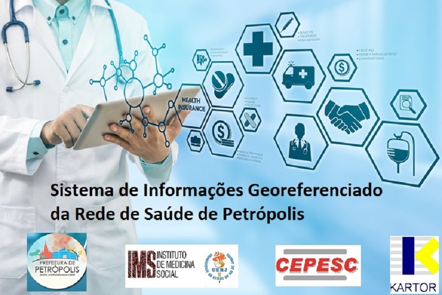
Petrópolis Health Network
CEPESC
- IMS/UERJ
|
|
|
|
|
The mapping of health teams and the data provided for the User Research and Diagnosis Project of the Petrópolis SUS network are two legacies of the geoprocessing system designed by KARTOR, under the coordination of the Institute of Social Medicine of UERJ.
The GIS supported the diagnosis of the network with demographic, neighborhood, distance and density indicators, fundamental data for proposing changes to the structure of the health network.
|
|
|
|
|
|
|
|
|
|
|
|
|
|
|
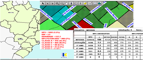
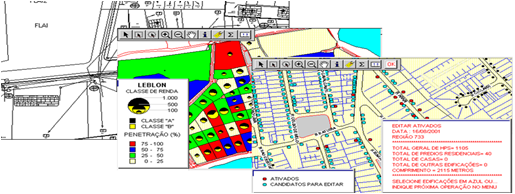
Stratregic Planning System
GloboCabo Holding
|
|
|
|
|
Kartor developed a decision analysis system for the start up of cable TV operations in 25 Brazilian cities.
The system calculated indicators of the different regions of the city by cross-referencing socio-economic data with urban infrastructure
data and geographic data.
This allowed to estimate, for each region, its implantation costs and the volume of potential clients. This approach made it possible to plan the priorities of building the wired network, ensuring a faster return on investment.
|
|
|
|
|
|
|
|
|
|
|
|
|
|
|
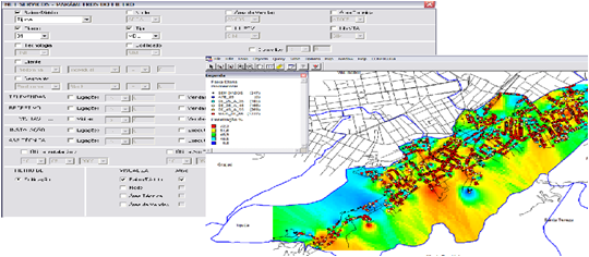
Business Inteligence (BI)
Net Serviços – cable TV operator
|
|
|
|
|
The application displays different sorts of maps showing the marketing share of the cable tv products along the city.
The user filters tv programs and the clients, by age and socio-economic profile, getting the results into reports and many types of thematic maps.
|
|
|
|
|
|
|
|
|
|
|
|
|
|
|
GIS for cable TV
Net Rio
|
|
|
|
|
KARTOR built the GIS for Net-Rio, the cable TV operator of Rio de Janeiro.
Project included the system modeling; address data cleaning; geocoding over 400,000 addresses (1:500); strategic planning, network design, production planning & control, operations, marketing and sales aplications.
|
|
|
|
|
|
|
|
|
|
|
|
|
|
|
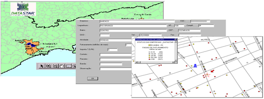
Sales System
DataStar – Last Mile Telecom Provider
|
|
|
|
|
Kartor developed a GIS-based Customer Relations Management System for a telecom provider located at Rio de Janeiro and São Paulo metropolitam areas.
When the sales personnel registers the customer’s data, the system locates the address in the map and analyzes the signal quality.
|
|
|
|
|
|
|
|
|
|
|
|
|
|
|
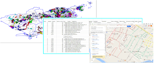
Routing Research and Selling Teams
Logbit
|
|
|
|
|
The system uses clustering and routing methodologies to build the logistics of research and sellers teams along Coca Cola outlets.
It has been applied in the metropolitan areas of Rio de Janeiro, São Paulo, Fortaleza.
KARTOR also made a logistic project based on “blind research” for Coca Cola in Thailand.
|
|
|
|
|
|
|
|
|
|
|
|
|
|
|
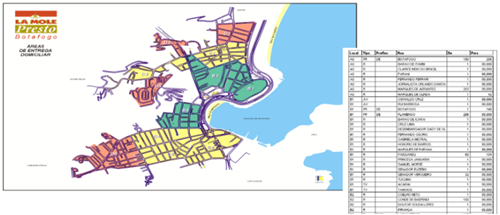
Delivery System
la Mole Chain
|
|
|
|
|
KARTOR developed the delivery project for 12 restaurants of La Mole chain.
The delivery districts and routes were designed taking into account distance, travel times and market concentration.
|
|
|
|
|
|
|
|
|
|
|
|
|
|
|
|
|
|